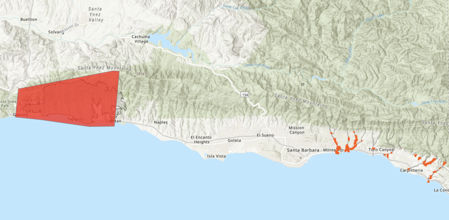
The atmospheric river hitting the Central Coast and the rest of California is intensifying, leading to evacuation orders for areas near burn scars in Santa Barbara County.
There are mandatory evacuations for the Thomas Fire burn scar in Montecito, the Alisal Fire burn scar in Gaviota and the Cave Fire burn scar in the Santa Ynez Mountains.
Click here for an interactive map of the evacuation areas.
Santa Barbara County Sheriff Bill Brown said at a press conference this afternoon that 10 inches of rain could fall in these areas as the storm picks up, creating high risks for flooding and debris flow.
Residents can access Santa Barbara County’s emergency response website at readysbc.org, or call 211 for more information.
The county says the SBCC Wake Campus located at 300 N Turnpike Rd, Santa Barbara, CA 93111 is set up as an evacuation center.
A 24-hour call center has been set up at (833) 688-5551.
For animal evacuation information, call Santa Barbara County Animal Services at (805) 681-4332 or the County Animal Services after-hours phone line at (805) 683-2724.
The burn scar areas are under an evacuation order, which is a lawful order to leave immediately because of an immediate threat to life. Evacuation warnings means there is a potential threat to life and or property, but it is not mandatory to leave.
Both warnings and orders can also happen near places besides burn scars — especially rivers, creeks, and places prone to mud or rock slides like Big Sur. The city of Paso Robles issued an evacuation warning yesterday for the areas near the Salinas Riverbed within city limits.
There is also a flood watch for all of the Central Coast from now until at least 10a.m. tomorrow.
In San Luis Obispo County, some areas of Avila Beach, Pismo Beach, Oceano, Arroyo Grande and Morro Bay are at risk of flooding according to the Federal Emergency Management Agency (FEMA).
To find dispatch numbers, hotlines, warming centers, where to find sandbags and more, visit readyslo.org for SLO County, readysbc.org for Santa Barbara County and this link for Monterey County Emergency Services.
For information on local highway conditions, visit CalTrans District 5’s website or Twitter. Local weather conditions are online at the National Weather Service website, weather.gov.


